Auckland Coastal Survey Pictures

Post Options Post Options   Likes (5) Likes(5)   Quote Clifftastic Quote  Post ReplyReply Direct Link To This Post Topic: Auckland Coastal Survey Pictures
    Posted: 13 Jun 2013 at 12:26pm
Clifftastic View Drop Down
Platinum
Platinum
Avatar

Joined: 14 Mar 2012
Location: Te Atatu Pen
Status: Offline
Points: 2164
Just wondering if the Auckland based rock fisho's are aware of the coastal survey photos that are available on the Council's GIS viewer? Its a pretty cool resource for checking out the lie of the land viewed from the sea back toward the coast.
 
They cover a huge amount of the Auckland and Gulf Islands (some) coastline and the pictures are clear, have a zoom option and a recent.
 
To view, go to Council website www.aucklandcouncil.govt.nz and open up the GIS viewer. Then -

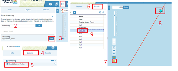
1. Open up the Map content folder on the right of the screen

2. Click on the green + sign at the top

3. Then click on the empty box beside LiveMaps/Monitoring and click Add layer to map

 
4. Now open Monitoring layer and tick the Coastal Survey Photos box
 
5. You should see thousands of small camera icons appear over the coastline
 
6. Zoom in to wherever takes your fancy - i'm at the sw corner of Waiheke here, then open up the Identify (i) box
 
7. Click on the big blue i button, then click on which camera view you would like to see
 
Now click on the View photo button in the grey box and it will bring up the view.
 
Hope its easy enough to follow!
Back to Top
Post Options Post Options   Likes (0) Likes(0)   Quote EditB Quote  Post ReplyReply Direct Link To This Post Posted: 13 Jun 2013 at 12:28pm
EditB View Drop Down
Platinum
Platinum
Avatar

Joined: 22 Dec 2008
Status: Offline
Points: 2657
That's awesome! Cheers bro
I do not lie about fishing, I willingly participate in a campaign of misinformation.
Back to Top
Post Options Post Options   Likes (0) Likes(0)   Quote Finatic Quote  Post ReplyReply Direct Link To This Post Posted: 13 Jun 2013 at 12:46pm
Finatic View Drop Down
Titanium
Titanium
Avatar

Joined: 09 Jan 2006
Location: Here
Status: Offline
Points: 17197
Awesome! Thanks heaps for thisThumbs Up< id="adlesse_unifier_magic_element_id" style="display:none;">
What's the cheapest type of meat? Dear balls. They're under a buck.
Back to Top
Post Options Post Options   Likes (0) Likes(0)   Quote fisher Quote  Post ReplyReply Direct Link To This Post Posted: 13 Jun 2013 at 1:41pm
fisher View Drop Down
Gold
Gold
Avatar

Joined: 17 Mar 2006
Status: Offline
Points: 799
Brilliant! Thanks very much, very useful mate.
North Shore Surfcasting Club
Back to Top
Post Options Post Options   Likes (0) Likes(0)   Quote Clifftastic Quote  Post ReplyReply Direct Link To This Post Posted: 13 Jun 2013 at 2:35pm
Clifftastic View Drop Down
Platinum
Platinum
Avatar

Joined: 14 Mar 2012
Location: Te Atatu Pen
Status: Offline
Points: 2164
No worries fellas
Back to Top
Post Options Post Options   Likes (0) Likes(0)   Quote SufixRockMan Quote  Post ReplyReply Direct Link To This Post Posted: 13 Jun 2013 at 4:15pm
SufixRockMan View Drop Down
Platinum
Platinum
Avatar

Joined: 02 May 2010
Location: Nelson
Status: Offline
Points: 2876
what a awesome resource, thanks clifftastic!
Back to Top
Post Options Post Options   Likes (0) Likes(0)   Quote mouthu Quote  Post ReplyReply Direct Link To This Post Posted: 13 Jun 2013 at 5:56pm
mouthu View Drop Down
Titanium
Titanium
Avatar

Joined: 20 May 2007
Location: Westie
Status: Offline
Points: 6359
Bloody hell, I use the council GIS every day almost and never would've known that was there. Good job.
Yes it was me, I screwed it up for everyone.
Back to Top
Post Options Post Options   Likes (0) Likes(0)   Quote Jwest Quote  Post ReplyReply Direct Link To This Post Posted: 13 Jun 2013 at 7:19pm
Jwest View Drop Down
Silver
Silver


Joined: 09 Jan 2012
Status: Offline
Points: 454
Thats wicked, nice one Clifftastic!
Back to Top
Post Options Post Options   Likes (0) Likes(0)   Quote C A Quote  Post ReplyReply Direct Link To This Post Posted: 13 Jun 2013 at 7:51pm
C A View Drop Down
Platinum
Platinum
Avatar

Joined: 05 Jan 2011
Location: East Coast
Status: Offline
Points: 2346
mean cheers dude
Back to Top
Post Options Post Options   Likes (0) Likes(0)   Quote MrWildabeast Quote  Post ReplyReply Direct Link To This Post Posted: 14 Jun 2013 at 10:11am
MrWildabeast View Drop Down
Silver
Silver
Avatar

Joined: 31 May 2011
Location: Tauranga
Status: Offline
Points: 453
wicked!!
Here fishy..fishy....
Back to Top
Post Options Post Options   Likes (0) Likes(0)   Quote khaled eid Quote  Post ReplyReply Direct Link To This Post Posted: 09 Mar 2019 at 6:46pm
khaled eid View Drop Down
Bronze
Bronze


Joined: 24 Aug 2003
Status: Offline
Points: 17
Hi 
They change the web site can you provide the link to the new interface 
Back to Top
Post Options Post Options   Likes (0) Likes(0)   Quote Munsterdog Quote  Post ReplyReply Direct Link To This Post Posted: 20 Oct 2023 at 9:15am
Munsterdog View Drop Down
Bronze
Bronze


Joined: 22 Oct 2014
Status: Offline
Points: 67
Hi all,
I found this old post and note this information is still available at the new maps interface:
https://geomapspublic.aucklandcouncil.govt.nz/viewer/index.html

Hopefully the screenshots below helps with the steps in number order, essentially:
1,2,3 - > search for and add 'monitoring'
4,5 - > add coastal survey photos under the legend tab.
6,7,8 -> click 'info' button, double click a photo icon (zoom in to display them)
 9 -> link to photo.

Back to Top
Post Options Post Options   Likes (0) Likes(0)   Quote TheFisherMartian Quote  Post ReplyReply Direct Link To This Post Posted: 23 Oct 2024 at 9:20am
TheFisherMartian View Drop Down
Bronze
Bronze


Joined: 13 Sep 2024
Status: Offline
Points: 1
Thanks Munsterdog! Super helpful.

In case anyone else is having trouble seeing any results when double clicking the photo icon, here's what worked for me.

After adding coastal survey photos under the legend tab, use the "select" tool (cursor icon on the toolbar).

In the "select" pop up, within the "spatial query" tab, tick "Select by feature using features from source". Then select "Coastal Survey Locations" in the dropdown menu. Finish by clicking "Apply".

This will now let you click on photo icons and you can go to step 9 as per Munsterdogs post.


Back to Top
Forum Jump
Forum Permissions View Drop Down


This page was generated in 1.547 seconds.

Fishing Reports Visit Reports

Saltwater Fishing Reports
Top of the South Fishing Report - 23/01/26

Snapper, cod and marlin on the menu Despite the weather we have had recently, when... Read More >

23 Jan 2026
Saltwater Fishing Reports
Bream Bay Fishing Report - 23/01/26

Snapper out deep in cooler water As happens at this time of the year, the... Read More >

22 Jan 2026
Saltwater Fishing Reports
Inner Hauraki Gulf Fishing Report - 23/01/26

Small snapper the norm Over the last 10 years I have noticed with great concern the... Read More >

22 Jan 2026
Freshwater Fishing Reports
Rotorua Fishing Report - 23/01/26

Fishing will be exceptional when water clears The massive amount of rainfall to hit the... Read More >

22 Jan 2026
Fishing bite times Fishing bite times

Major Bites

Minor Bites

Major Bites

Minor Bites