Project - V.High Def Bottom Maps

Post Options Post Options   Likes (0) Likes(0)   Quote Haydan Quote  Post ReplyReply Direct Link To This Post Topic: Project - V.High Def Bottom Maps
    Posted: 23 Jun 2010 at 7:06pm
Haydan View Drop Down
Silver
Silver


Joined: 17 Jan 2006
Location: Tauranga
Status: Offline
Points: 402
I'm after a little help and feedback on an idea I have;
 
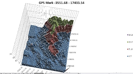
The idea is to get a good combo unit (Furuno or HDS) and do grid scans over popular fishing spots (spot x's) on days that are calm with little swell. Once thats done extract the GPS co-ordinates and depth soundings and graph it to create a very detailed chart of the ocean floor of that area.
 
I've written the program to create the graph and it works really well now I just need to find a suitable combo unit that will output the data that I need. Does anyone know of a combo unit that will do this?
 
If your interested in helping I'd love to get my hands on some data files from combo units so I can look to see if I can extract the co-ordinates and depths from it to do the project.
 
Below is an example of the kind of map that this system would put out, the bottom map has been created using 3 or 4 passes on one axis.
 
.
Back to Top
Post Options Post Options   Likes (0) Likes(0)   Quote Dead Ant Quote  Post ReplyReply Direct Link To This Post Posted: 23 Jun 2010 at 8:03pm
Dead Ant View Drop Down
Platinum
Platinum
Avatar

Joined: 04 Feb 2003
Location: Saint Kitts
Status: Offline
Points: 2502
Haydan,

Most GPS fishfinder combo's will do this if they have an NMEA 0183 output.  You need to connect this to the serial port (or USB serial converter) on a laptop and turn on the GPS and Depth sentences.  You can then turn on a telnet program like Hyperterm and connect to the device.  It will spit out a heap of information which you then need to turn into X,y,z coordinates. 

I found it to be well worth it for uncharted / poorly charted waters which is much of NZ!

It's all doable and fun but there are a few programs will will do it for you.  Some are on the expensive side like Maxsea and Olex but DrDepth may be a cheap alternative.  I think that if you plug the DrDepth program into a Lowrance unit it will even do bottom descrimination which would be really nice.

http://drdepth.se/ is the site available for 79 euros.

The best in the market is a locally developed program called WASSP which is developed by ENL. 

Let us know how you get on.

Cheers

DA

Back to Top
Post Options Post Options   Likes (0) Likes(0)   Quote Haydan Quote  Post ReplyReply Direct Link To This Post Posted: 24 Jun 2010 at 4:49pm
Haydan View Drop Down
Silver
Silver


Joined: 17 Jan 2006
Location: Tauranga
Status: Offline
Points: 402
Dr Depth looks bloody interesting. Going to be pretty expensive to set up by the looks, $1500 for the combo unit, $1000 for the adapter to make it work with Dr Depth, Dr Depth itself ($300 if I want it to record bottom hardness which I do) and another $1000 for a computer so I can do it on the fly out fishing.
 
Total Cost ~$4000
 
Right time to start saving.
Back to Top
Post Options Post Options   Likes (0) Likes(0)   Quote johnny_A Quote  Post ReplyReply Direct Link To This Post Posted: 24 Jun 2010 at 6:49pm
johnny_A View Drop Down
Gold
Gold
Avatar

Joined: 17 Jul 2002
Location: New Zealand
Status: Offline
Points: 673
Haydan - Looks cool.  PM sent. 

DA - That WASSP stuff is amazing, wish I had a unit like that!
Back to Top
Post Options Post Options   Likes (0) Likes(0)   Quote Dead Ant Quote  Post ReplyReply Direct Link To This Post Posted: 25 Jun 2010 at 2:55am
Dead Ant View Drop Down
Platinum
Platinum
Avatar

Joined: 04 Feb 2003
Location: Saint Kitts
Status: Offline
Points: 2502
Haydan,

Most units come with an NMEA cable so there should be no extra cost apart from a serial cable ($20) and a cheap laptop ~ $300 so should be alright.

Cheers
Back to Top
Post Options Post Options   Likes (0) Likes(0)   Quote Haydan Quote  Post ReplyReply Direct Link To This Post Posted: 25 Jun 2010 at 8:09am
Haydan View Drop Down
Silver
Silver


Joined: 17 Jan 2006
Location: Tauranga
Status: Offline
Points: 402
Oh your right, the HDS units can output NMEA 0183 Clap
Back to Top
Post Options Post Options   Likes (0) Likes(0)   Quote Beak Quote  Post ReplyReply Direct Link To This Post Posted: 18 Jul 2010 at 9:01am
Beak View Drop Down
Bronze
Bronze
Avatar

Joined: 04 Mar 2008
Location: Netherlands Antilles
Status: Offline
Points: 94
Lowrance units can save the GPS and depth data to an SD card which can be transferred to a PC and played back. 
Back to Top
Forum Jump
Forum Permissions View Drop Down


This page was generated in 0.156 seconds.

Fishing Reports Visit Reports

Saltwater Fishing Reports
Raglan Fishing Report - 12/11/26

Big spring snapper. With the more settled weather over the last couple of weeks there’s... Read More >

12 Nov 2026
Saltwater Fishing Reports
Mercury Bay Fishing Report - 12/11/26

Snapper hit and miss. Most reports have been telling us it’s becoming more difficult to... Read More >

12 Nov 2026
Saltwater Fishing Reports
Northland Fishing Report - 12/11/26

The switch has been flicked on! Call it what you want, El Niño, global warming,... Read More >

12 Nov 2026
Saltwater Fishing Reports
Tauranga Fishing Report - 12/11/26

Snapper and kahawai in close. Again, we start on a positive note, with some nice... Read More >

12 Nov 2026
Fishing bite times Fishing bite times

Major Bites

Minor Bites

Major Bites

Minor Bites