Lowrance Elite 9 Ti
Printed From: The Fishing Website
Category: Saltwater Fishing
Forum Name: The Briny Bar
Forum Description: The place for general chat on saltwater fishing!
URL: https://www.fishing.net.nz/forum/forum_posts.asp?TID=137113
Printed Date: 19 Sep 2026 at 11:35am
Topic: Lowrance Elite 9 Ti
Posted By: smudge
Subject: Lowrance Elite 9 Ti
Date Posted: 27 Oct 2022 at 7:08pm
I've just replaces my trusty Lowrance Globalmap and Garmin 620 FCV with a Lowrance Elite 9Ti. It has side scan. I've never used sidescan before but have to say it worked a treat on it's first trip out in 'conventional mode. No adjustments needed  Any clues as to how sidescan works? I was too busy hanging on to get adventurous, on a calmer day I would have had a play. Nice unit though. ------------- Best gurnard fisherman in my street |
Replies:
Posted By: kimber7wsm
Date Posted: 28 Oct 2022 at 6:01am
|
Mike Smedley on Youtube does some good stuff on that sort of thing. That way you get to see what he's talking about in action |
Posted By: letsgetem
Date Posted: 28 Oct 2022 at 3:43pm
|
I had a Elite 7. I looked at sidescan once; but couldnt see anything of interest. I recall reading someones advice, that sidescan would show the sea bed out each side, but objects such as fish would be difficult to see, being so small and indistinct. I decided it was a gimmick, not actually useful. But you should use it and see, I might be wrong? Interesting - I changed from Lowrance Elite to Garmin 95SV; and the garmin sonar appears significantly better.
|
Posted By: smudge
Date Posted: 28 Oct 2022 at 7:10pm
|
Thanks Kimber & Lets. I'll check it out on youtube. The FF works really well on 'conventional' mode and we had a great catch but we didn't see any action on the ff, just like the Garmin but yeah the FF was an improvement overall and the Chart Plotter does a good job. just didn't get a chance to try sidescan. It was hard enough holding on with a robust west coast chop doing its best to hurt my old knees. ------------- Best gurnard fisherman in my street |
Posted By: kimber7wsm
Date Posted: 29 Oct 2022 at 6:10am
|
I find Sidescan really useful for finding structure. Particularly when snorkeling for crays. It's very good for finding the sand/reef edge as well. I have the Active Imaging unit from Simrad/Lowrance. From what I've been told it's significantly better than earlier Simard units. It doesn't work at speed as well as conventional sonar. So you have to slow down a bit. Smudge, if you have the Active Imaging transducer and find you get clutter on your screen when traveling with CHIRP, change your frequency to 200. Fixed frequencies read much better than chirp at speed. When you slow down at point of interest change back to CHIRP and it will give better definition.
|
Posted By: smudge
Date Posted: 29 Oct 2022 at 7:23am
|
OK thanks for that. I watched a bit of You Tube but I'll just have to go have a tutu with it now.
------------- Best gurnard fisherman in my street |
Posted By: The Tamure Kid
Date Posted: 29 Oct 2022 at 6:11pm
|
I'm not much of an electronics guy, so the technical data about hertz etc means nothing to me Smudge, but as mentioned above, SideVu (Garmin) or side scan is very useful for identifying where reef meets sand or other structure. That makes it an excellent tool for slowly fishing around coastlines, with lures in particular I guess, though it would be helpful for positioning at anchor to strayline with berley. I don't use it in deeper water over sand - usually just use the traditional view to see sign.
The main thing to remember with side scan is that the top of the screen where the black line starts is the stern of the boat, so everything you see on screen (out either side) is what you've already passed. No point seeing a rock and casting towards it as if it's what is actually beside you, as it will be well behind you by that point. As i understand it, the black top to bottom 'stripes' on the screen represent the water depth on the distance scale from the white line in the middle, which is your transducer; of course the distance out to the side the various objects are is measured by the scale along the bottom of the screen too (in feet or metres depending on your settings). So if it's 8m deep where the boat is, the black stripe on the left will be 8m on the scale to the left of the white stripe, and the black stripe to the right will be 8m on the right scale. Once the beam hits the bottom it turns out to each side, like a torch light - which creates the 3D effect that you see - shapes and the shadows behind them. This screen shot is from a helpful YouTube explanation i've watched a few times. 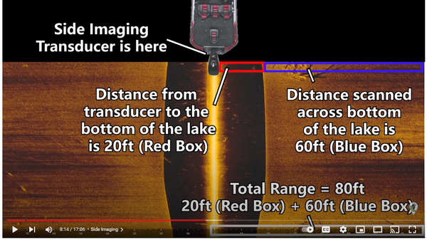 I think if you have a touch screen (which I don't), when in side scan mode you can touch a point on the screen e.g. a bit of reef as a 'mark' and then use that on the chart view to drift over later or fish back to with bait. On YouTube I have seen it used by estuary fishos in northern Australia to identify individual barramundi (and in one case a huge shark) but I'm not sure if they have special transducers or use a particular resolution. They see the fishes' shadows on the bottom. that may be more effective in shallow water like an estuary than in 20m+? I understand you can use it to see if a channel marker has kingies under it - which would be cool on your run up the harbour before you hit the bar. |
Posted By: smudge
Date Posted: 30 Oct 2022 at 5:36am
|
Thanks TTK, that's a lot to take in. I know a few places in the harbour with some big rocks, I'll have to try it out there.
------------- Best gurnard fisherman in my street |
Posted By: The Tamure Kid
Date Posted: 30 Oct 2022 at 10:19am
|
I know what you mean - side scan is not easy to get your head around if you are used to the idea of the fish finder just showing straight to the bottom. There are endless vids on youTube - some are specialist ones for particular brands - but I found this one about basic misconceptions quite helpful. It's where I got the screen shot above. It's by a US bass fisherman, but the concepts apply to our salt water fishing. https://www.youtube.com/watch?v=VwWqwN28pFw&t=908s%20" rel="nofollow - https://www.youtube.com/watch?v=VwWqwN28pFw&t=908s
|
Posted By: Joker
Date Posted: 31 Oct 2022 at 2:27pm
|
One of the better side images of 1M kingfish racing back to the protection of "A" buoy in Auckland taken on a Garmin 7412 with GT51 tranny. Kingfish are the group of dots in the left hand black bit and the shadows of these fish are shown on the green bottom to the left. Odd patches of bait fish overlaid on the right though hard to see as the fish wash out with the bottom. 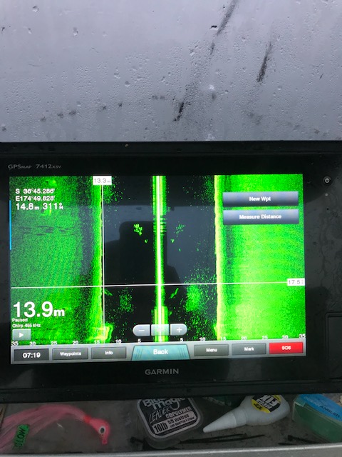 |
Posted By: Joker
Date Posted: 31 Oct 2022 at 2:30pm
A couple more for good measure.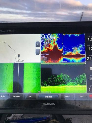 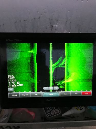
|
Posted By: smudge
Date Posted: 01 Nov 2022 at 6:13am
|
That's interesting Joker. I'm guessing the kings are 15ft off the bottom in the first pic?
------------- Best gurnard fisherman in my street |
Posted By: Joker
Date Posted: 01 Nov 2022 at 9:29am
Yes at 5 metres and the shadows are cast at 45 degrees onto the bottom. They have to be pretty big fish to cast a shadow in this depth even on such a big screen. |
 smudge wrote:
Posted By: Joker
Date Posted: 01 Nov 2022 at 9:37am
|
What is a real game changer is the C-map Reveal and Garmin G3 technology available on newer models with faster chips. This overlays the bottom structure onto the GPS charts in much more detail that looks nothing like the regular charts. Check out this shot of Flat Rock and compare it to Navionics Web App - no comparison. https://www.actionoutdoors.kiwi/epages/shop.sf/?Locale=en_NZ&ObjectPath=/Shops/ActionFishing/Products/M-AU-Y622-MS&ViewAction=ViewProductViaPortal&cmp_id=1034294347&adg_id=107464844786&kwd=&device=c&gclid=EAIaIQobChMI7falhaiL-wIV4JlmAh2v3gByEAQYAiABEgLZ0fD_BwE" rel="nofollow - https://www.actionoutdoors.kiwi/epages/shop.sf/?Locale=en_NZ&ObjectPath=/Shops/ActionFishing/Products/M-AU-Y622-MS&ViewAction=ViewProductViaPortal&cmp_id=1034294347&adg_id=107464844786&kwd=&device=c&gclid=EAIaIQobChMI7falhaiL-wIV4JlmAh2v3gByEAQYAiABEgLZ0fD_BwE |
Posted By: letsgetem
Date Posted: 01 Nov 2022 at 9:55am
| CMap reveal - Thats brilliant. I presume its not for Garmin, as they bought Navionics, so since then the others Lowrance etc, have been improving Cmap. Thats an interesting example of what happens when you try and take over the market in marine maps. |
Posted By: Joker
Date Posted: 01 Nov 2022 at 10:34am
|
Navionics have their own version called G3 and available on Garmin sounders - its the same detail source. I have a friend and very successful softbait fisherman who uses C-map reveal to target the very edges of reefs around Rangitoto using this technology to position his drifts perfectly. |
Posted By: kimber7wsm
Date Posted: 02 Nov 2022 at 7:28am
|
C-Map reveal is bleedin awesome. I've used it to find rocks way out in the middle off nowhere in the deep. I went away from Navionics, because I did not like that they want a yearly payment to maintain full functionality. If I pay $300-$400 for some thing I shouldn't then have to pay $70 a year to use it. Garmin is like that.
|