Phone app chart plotter
Printed From: The Fishing Website
Category: General Forums
Forum Name: Tech Topics
Forum Description: IT - Computers, software, phones, ISP's....
URL: https://www.fishing.net.nz/forum/forum_posts.asp?TID=130015
Printed Date: 28 Jul 2026 at 3:13pm
Topic: Phone app chart plotter
Posted By: MB
Subject: Phone app chart plotter
Date Posted: 14 Jan 2019 at 11:58am
|
I'm looking for a phone chart plotter app. It'll just be a backup in case my main unit fails, so doesn't need to be flash, just have reasonably detailed charts and show me where I am. Navionics is the obvious choice, but now seems to need an annual subscription which I'd rather avoid. Happy to pay once though. Any suggestions? Cheers.
|
Replies:
Posted By: Steps
Date Posted: 14 Jan 2019 at 4:21pm
|
When your subscription expires you still have all your maps markers and stuff but cant update the maps. You will that other apps tend to run on the lower detail LINZ maps which , besides less detail, can be rather out dated in comparison I also believe you can load ther navionics, full version for limited time .. then cant update. Also note that if run navionics maps on your gps, your markers , routes , tracks get uploaded , and get synced onto your phone/ tablet and visa versa...  Bottom line, if annual subscription is an issue, then personally I would still be gong for the 'free' version navionics over the others.
|
Posted By: bigred1
Date Posted: 14 Jan 2019 at 6:56pm
| $35 a year for Navionics is a cheap GPS unit, that goes across devices (ipad gives you a 10" screen). That said Navionics also offers a two week free trial, so you really have nothing to lose. The only downside is you need cellphone coverage, e.g. telecom has none down the east coast area. |
Posted By: MB
Date Posted: 14 Jan 2019 at 7:56pm
| I thought Navionics was going to be the answer, but don't see a 'free' options for anything other than a two week trial. Also, I didn't think you needed cellphone coverage if you have the relevant maps downloaded on a device with a GPS chip? |
Posted By: bigred1
Date Posted: 14 Jan 2019 at 9:09pm
| The app (and the maps) download onto your device, after the trial it still remains but the quality drops back. In theory your phone GPS tracker can work directly with the satellites, in practice you need to access the internet, hence you need coverage-just so that big brother knows where you are. |
Posted By: MB
Date Posted: 14 Jan 2019 at 10:19pm
| cheers |
Posted By: Otto
Date Posted: 15 Jan 2019 at 7:03am
| Marine NZ i use as a back up or when i'm on another boat |
Posted By: Sufishent
Date Posted: 15 Jan 2019 at 9:58am
|
https://wetmaps.co.nz" rel="nofollow - wetmaps.co.nz is what you want - merges street, terrain, satellite, navionics and navionics sonar and LINZ charts
------------- You can never have enough fishing tackle |
Posted By: MB
Date Posted: 15 Jan 2019 at 4:46pm
Looks good, but looks like you need a 3G/4G connection.
|
 Otto wrote:
Posted By: MB
Date Posted: 15 Jan 2019 at 4:47pm
Nice maps, but again, lack of download options as far as I can see.
|
Posted By: Steps
Date Posted: 15 Jan 2019 at 5:51pm
|
Navoinics dont need cell coverage... just need a cell phone or tablet that has GPS sensors..for gps location satellites which I think all do now after about Adroid 4 or 5 thats maybe 6 yrs ago now. Yep if navionics revert back after a couple weeks , you still have basically the latest LINZ maps except updated to when expiry ran out The wetmaps thats rather cool.. did the download , but it looks like a zip file and the contents the contents of a web page without the index page?? The other options... Which has been a while since looked at, but should meet your requirements are OpenCPN .. Max sea ?? embark Osmand marine plug in.. thu from memory have to buy the base program...great app for street navigation on a phone. seamaps ... was rather primitive when looked.. and rather dated from memory.. Comes back to navionics and in my books, pay the subscription, and being able to sync the gps to your phone.. able to update notes , routes , tracks, markers while at work or where ever then have the gps sync them back... At less than 75c per week. Then throw all the other stuff.. tides weather currents up to date maps etc..
|
Posted By: MB
Date Posted: 15 Jan 2019 at 6:53pm
| cheers steps. i use a gps app for hunting and no cellular coverage required, so that makes sense. |
Posted By: Otto
Date Posted: 16 Jan 2019 at 7:25am
Don't think so as if i've set my phone to aeroplane mode and the WiFi's off still works. Used it when in China to find my way around since google wasn't aloud.
|
Posted By: MB
Date Posted: 06 Feb 2019 at 1:08am
|
Update: 1. Navionics past the free subscription period is pretty much a waste of time in terms of chart detail. 2. Marine NZ works, but you need a data connection. It's a shame there isn't a map download option because it's a nice, simple app. 3. wetmaps.co.nz looks great on a desktop, but I have no idea how I would use this as a chartplotter on an iphone. In the meantime, I have found iSailGPS NZ. It is from the same stable as iHikeGPS-NZ. I use the latter when hunting in the bush with no cell coverage and it has got me home every time. Hopefully, iSailGPS NZ will be just a useful. Had a play with it today and while you wouldn't want it as your main chartplotter for fishing purposes, it does seem to do the job without any frills. |
Posted By: like_to_strike
Date Posted: 06 Feb 2019 at 7:54am
|
I have had navionics for at least 5yrs, my subscription ran out years ago and i did not lose any map detail. I am fairly sure while your subscription is expired you dont get map updates from navionics or other users not lose map detail. Here is a few screenshots 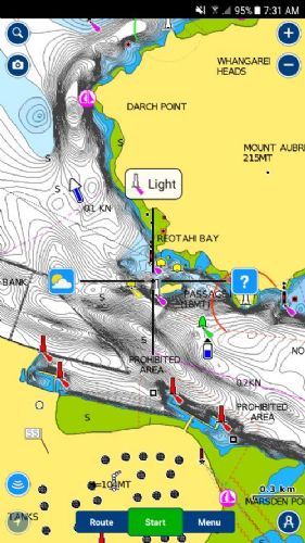 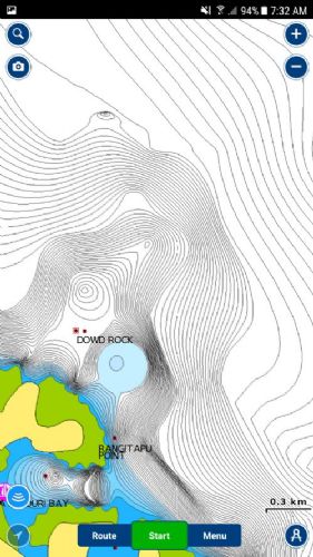 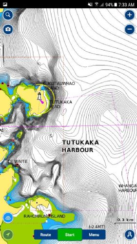 |
Posted By: Steps
Date Posted: 07 Feb 2019 at 8:11am
|
I have had navionics for at least 5yrs, my subscription ran out years ago and i did not lose any map detail. I am fairly sure while your subscription is expired you dont get map updates from navionics or other users not lose map detail. I believe that is correct and that is also what it says on the download page descriptions
|
Posted By: MB
Date Posted: 07 Feb 2019 at 8:57am
| OK, I'll give it another go. |
Posted By: Steps
Date Posted: 07 Feb 2019 at 9:06am
|
Subscription is about $30/ yr thats about the amount of Brand name 2S oil I go thru from Te Torro, over the bar to 30m mark.. And yeah those map updates.. 99% of the time you will never notice anything.. then once in a while.. east coast, a reef one frequents shows up a gutter you didnt know was there.. Or West coast and harbours...a change in channels.. dont get too close to certain markers. I have the tab with navionics plus the old huminbird as a gps...yep one sees the changes esped after extreme weather one in 100 yr storms that come in every yr now..
|
Posted By: MB
Date Posted: 07 Feb 2019 at 10:49am
This is what I'm getting (and the "SonarChart" option isn't available). Guess you have to pay at least once to get the detailed charts. |
Posted By: lika
Date Posted: 09 May 2019 at 10:21am
| Nice maps, but again, lack of download options as far as I can see. |
Posted By: Catchelot
Date Posted: 09 May 2019 at 2:06pm
|
Have a look at Embark Andy, its not bad.
------------- "The sea, once it casts its spell, holds one in its net of wonder forever." - Jacques Cousteau |